Wednesday 29 August 2007

Kingston Road, Wimbledon SW19

Map location

Kingston Road runs along the southern edge of Wimbledon up to its border with the leafy environs of Merton Park. There’s an air of civic virtue in the buildings compared to those going the other way toward Tooting – Masonic lodges, Salvation Army, Clubs, St. Johns Ambulance, colleges and council buildings all to be found within a few hundred yards of each other. There are still roads full of small Victorian and Edwardian cottages to the north and still lots to be seen above the frontage but this is definitely a road of plaques and inscriptions.

1) Starting off from Pincott Road I noticed a pub sign that I’d missed before. Although now ‘The Kilkenny Tavern’ it seems it was previously known as ‘The Dark House’, which has to be one of the least uplifting pub-names ever!

2) Crossing over by South Wimbledon tube and we are in Kingston Road proper

3)There’s a fine building down on the left hand side with a neat metal sign over the entrance. Now known just as ‘The Manor Club’ it now hosts concerts and is hired out for functions.

The interesting thing on this plaque is not so much the fact that it opened in 1890, but that the president of the club was John Innes esq. He of the horticultural fame who is probably best known as founding The John Innes Institute and having a range of potting compost named after him. I don’t know much about the club's history or original purpose although as John Innes was Lord of the Manor of Merton it might be named 'The Manor Club' a bit of self-aggrandizement!

4)Slightly further down the road is the Merton Masonic Lodge with another intriguing inscription. ‘Be Traist’ doesn’t seem to be a specific Masonic motto but a bit of searching on the internet reveals that it means ‘Be Faithful’ and, (surprise, surprise) just happens to be the motto of the Clan Innes! What are the chances of John Innes also being the first Grand Master of the Lodge? I’m not sure about the crest though although I suppose there’s a good chance that it’s his as well…

5) No longer used by the council these offices are elegant and again part of the development of the area at the turn of the century.

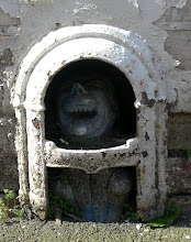
6)Just a few feet down is a building definitely not from the turn of the century but still dedicated to the public good. The slightly battered emblem from the St John Ambulance yard.

7) Some nice tile work between the shops heading down toward the tram lines. I might be tempted to do a collection just of this sort of tile work as it always provides a quality comparison to the modern paint and plastic that usually surround it

8)I crossed over at the tram line at Hartfield Road to take a look at one of my favourite local buildings, now boarded up. It is the shape of a very thin slice of cake and used to go by the name of ‘Ju-Ju Dinner Jackets Café’. A real exercise in squeezing the maximum of space out of a site!


9) Heading back to South Wimbledon on the other side of the road I spotted this on the wall above a Chinese take away. A good luck sign maybe?

10) Checking the dates it's apparent that this old street sign hasn’t been touched since at least 1965 when the Borough of Wimbledon was abolished.

11) One of a row of about six of these ‘Improved Patent Safety Plate’ coal-hole covers in front of a row of shops.

12)This plaque was one of two on the Wimbledon School of Art. Apart from being a teacher with two pupils I’m not sure if it has any deeper significance.

13) You can't miss this this slightly naïve and odd looking bit of wall art on the corner of Palmerston Road. From the ornate quality of the windows and general layout I believe it was originally a pub called the Lord Palmerston. In fact I’m pretty sure I remember it operating as such about five years ago.

14) The last plaque of the walk belongs to the Salvation Army and is a bit boring to be truthful. It’s too high to have a look at what seems to be quite an ornate pattern and it looks as though it’s been stuck on as a bit of an afterthought.

15) Back near Pincott Road again and my eye was caught by this lively but crumbling bit of tiling above a motorcycle shop. I couldn’t think what the building might originally have housed and the only thing I could tie in with its rakish demeanour was something like a billiard hall, although it’s probably a bit on the small side. Any ideas?

Friday 24 August 2007

A Quick Stop in Garrett Lane SW18

Map reference

I was driving along Penwith Street across Garrett Lane and into Earlsfield Road when I saw a very faded painted sign high up on a wall at the crossroads. I decided to stop and take a quick picture on my way back and was mighty pleased to see an even better wall painting on the way back down Earlsfield Road. After getting a picture of that one I parked near the crossroad to take a snap of the original sign. I was then tempted to take a quick stroll down the road for a few turnings in search of a few more old signs and wasn’t disappointed…

1) Visible only when approaching Garret Lane on Earlsfield Road, this is now on the side of a private residence but I hope they
aren’t tempted to paint over it. Actually I think I’d be tempted to have it restored.


2) This is the very obscure sign at the crossroad that caused me to stop in the first place. It looks as though it says ‘SPQ & …???’ Any idea what it refers to?


3) the plaque above apparently says Erected by
J. Doerr, H. Boulter, Builder, 1885


4)On the corner of Thornset Road, I think this portion of a sign only survived by being covered up for years as the rest of it seems to have been removed. I’m guessing that the shop in question was a Pawn Merchant and General Stores but I wonder where the other branch was?


5) I think this was on Skelbrook Street and a tantalising glimpse of a name. The ghost of a D is on the left followed by an A then what could be a P,B or R, E and N. So it’s DAPEN, DABEN or DRABEN?


6)And finally at Thorndean Street, Sullivans shop front is saved for posterity before a rebuild takes place. Some interesting stuff in only a few streets, and that was ignoring a lot of the architectural features. This is an area definitely worth another visit.

Colliers Wood High Street

Map of Route described


Another lunchtime stroll, this time leaving from South Wimbledon Tube Station and east along Merton High Street and into Colliers Wood just over the railway bridge and sniffing at the borders with Tooting. There was a surprising lack of painted wall signage but some interesting architectural features. Quite an enjoyable stroll all round…


1)First stop was the Admiral Nelson, a very ornate pre-first World War I pub covered in glazed and painted tiles, The two tiles sets face right onto the pavement and I’m amazed they haven’t been damaged or vandalized more than they seem to have been. Both sets of glazed tiles are dated and bear the name Carter’s, Poole 1910 in the bottom left hand corner. This company eventually became Poole Pottery and apparently did much of the art deco tile work for the London Underground


2) On the same site I also noticed a couple of these tiles whose message has been slightly lost over the years where, presumably frost and freezing has finally been taking its toll.


3)Quirky or naff, these signs were, I believe, designed after
a competition amongst local schools some years ago. There have been more recent and slightly more threatening efforts since then but there are still loads of these about the streets of Merton.


4) This plaque is on the side of the River Wandle by the footbridge to the Sainsbury’s and commemorates the presence of the William Morris mills. For a fairly shabby part of London there’s a surprising amount of history around these streets!


5)These photos show a monument just inside Wandle Park that has
inscriptions on three side. One side is pretty weather-beaten but these two are still quite legible and you can probably read them by clicking on the photo for a closer look. The park and monument was bequeathed by “John Feeney of Birmingham and Berkswell who loved nature and his fellow man” and was opened in 1907.


6) Down a bit further to the magnificent portico to the Royal Standard pub. No idea what it’s like inside but the façade is very eye-catching.


7) Down the road a few hundred yards and you come across the only piece of painted wall signage on the walk. It may be modern but it does the job


8) At this point there is a l
ong stretch of old, slightly run-down shops underneath Victorian buildings. As usual you have to look up to get an idea of their original quality and there are some nice touches to be found. Here, not particularly clearly, you can see the name plaque ‘Spring Cottages 1863’ and I’ve also tried to include the attractive top of a column amidst more modern fittings.


9)These two pictures show some ornate brickwork on one particular row and the date plaque of 1875 showing that it was built by William Clark and was probably quite smart when first completed. I also tried to capture the top windows as they were the only ones with the original iron retainers to presumably stop flowerpots being blown off the ledges!.


10) Slightly further along I spotted this lonely pot sitting on top of its column.
I assume there were originally a few more but they are long since gone and this one doesn’t look in too good a state either.


11) Just before the railway bridge now and you have to wonder ‘What on earth was this?’. Although now a workshop this building has an enormous flagpole and looks as though it used to have a grander entrance. Could it have been an early cinema or scout hut? If you have any idea please leave a note in the comment section below…


12) On the railway bridge now and a couple of road signs, old and new (so good they named it twice!)


13) Over the bridge and to the left is a row of what at first look like fairly run of the mill shops divided by pillars, most of which are pebble-dashed. There is a glorious and unexpected exception though. This column of ornate tiles shows just what is lurking beneath the dirt, painted textured coating that covers the rest of the pillars. It really does catch your eye as you walk by and brightens up an otherwise dingy parade.


14) At this point I could see over the cross-roads into Tooting and a very large and tempting plaque on the eaves of a large building but with iron-will and self-discipline I crossed over and headed back to South Wimbledon. I walked past this ordinary post-box was drawn back to it as the proportions didn’t seem quite right, being slightly slimmer than usual. When I looked closely at the royal crest I saw it was for Edward VII so was probably put in place son after the surrounding building were erected. Street furniture that’s still going strong and being used for its original purpose after 100 years!


15) I couldn’t resist recording the fact that at Colliers Wood tube station I went passed the Infamous ‘Tower’, recently voted one of London’s greatest eyesores and a building that everyone in Colliers Wood would love to see removed. It has been likened to a scorched, post –apocalypse bunker but no doubt someone will buy it, tart it up and sell the penthouse suites with their extensive views of London for mega-bucks.


And that’s it for another lunchtime. But I’ve seen glimpses of the riches of Tooting and I’ll be casting my net further to the east next time!

Wednesday 22 August 2007

A Quick Tour of South Wimbledon

Map Location

To kick off the blog I’ve undertaken a mammoth bonanza of a street fest in the area around my current place of work. To outsiders it may just look like a lunchtime stroll with my camera in a fairly run-down part of town with a bit of history, currently undergoing a bit of a resurgence – well maybe so but there were a few gems uncovered by renovation as well as some nice wall adverts.

1) I started off with a stroll down Station Road even though the station and indeed the railway itself, have long since gone. What has been left behind though are a couple of tatty but very attractive street lights with unusual mirrored reflectors. I checked with the Conservation Officer from the London Borough of Merton and it seems that these are the only ‘listed’ street lights in the borough. They date from 1900 and are unusual in that they were expressly designed for electricity and not converted from gas lights, which was the norm. Apparently local residents are pushing for them to be renovated and bought back to working condition but no-one is holding their breath at present.

2) After a quick stroll alongside the River Wandle I came out on Merton High Street and turning left toward South Wimbledon tube station I found some work going on at the junction with Grove Road with this original painted signage uncovered above a door. Who was Cliff and what did he sell in his Corner? Any information from old residents would be most welcome.


3) At the junction of Haydons Road with Merton High Street and just up on the wall was this intriguing bit of wall-signage. As you can see it’s very faint and only a small portion is on display but I’d be interested to know what the white ‘bubble’ effect is peeking out of the bottom – part of a Michelin Man possibly?

4) This one is still pretty legible, despite being partially obscured. It’s on the corner with Hamilton Road and now sits above a sewing machine shop although I assume it was originally a Gentleman’s Outfitters named Townsends, although that’s pure guesswork on my part as the first part of the name is concealed.


5)It’s a bit of a hike up to South Wimbledon tube before turning right down Merton Road and following it along until it turns sharp left into Wimbledon Broadway. There, looking straight at you, is the signage for some Dining Rooms. Was this an early restaurant or an early equivalent of the ‘greasy spoon’ café? Wonder what the food was like…


6) Almost opposite the dining rooms and only really visible if you are coming in the opposite direction, how about this for a splendid example of wall-painted signage? I’m not quite sure what it’s for but I was wondering if the ‘MA’ was the end of CINEMA. Anyway, it was open for long hours and was fun for all the family and it seems appropriate it’s now sited at the entrance to a comedy club.


7) That’s all I had time for so I made my way back to Merton High Street where
I took this last picture on the side of a block of flats opposite Nelson Road. The historically minded amongst you would have noticed the number of Nelson-related roads – the reason being that the flats to the south of Merton High Street were the site of Nelson and Lady Hamilton’s house, ‘Merton Place’ and the site from where he set off for the last time to meet the Franco-Spanish fleet at Trafalgar. It’s changed a bit since his time although you can now catch trout in the Wandle, just as he used to…